|
Welcome at 53° 19' N
6° 49' E  |
|
 |
|
|
Welcome at 53° 19' N
6° 49' E |
|
|
|
Oosterwijtwerd, willow-mound |
| In the Northern part of Groningen
you find an area which is called "Het Hogeland" meaning High
Land. Here, in the old district Fivelingo at 53° 19' N 6° 49'
E and some 10 km from the wetlands which we call the
Wadden, you will find a small village called
Oosterwijtwerd, consisting of 80 houses and farms and
inhabited by approximately 250 people.
The district Fivelingo gets its name from the river the Fivel, which sprang from a field in the north of Kolham and meandered through peat, bog and clay to end in the Fivel estuary at Eenum. Oosterwijtwerd was situated - just as Eenum was - outside the estuary and is one of the oldest villages. In 500 BC people lived here and were dependent on the ocean for their living. Next to fishing and trade they lived from the land. They threw up mounds to keep people and animals safe from high tides. In Holland such a mound is called "Wierde" or "Terp" |
|
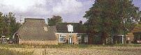
| In the eleventh century the Fivel-estuary started
to close with silt. Around this period the residents of this part of the
country constructed the first dikes, they constructed these dikes between
the higher situated places in the landscape. These dikes were also used
as roads and even now they are still in use and can still be recognized
by their meandering course. One of the most distinct examples of such
an old dike is the old road between Oosterwijtwerd and Holwierde.
Standing on this road
you can see the village of Oosterwijtwerd in the background. (Picture
of the right)
More recent roads run straight and parallel to each other. In the twelfth and thirteenth century most of the Fivel-estuary was reclaimed from the sea and the landscape which emerged is distinctly different from the older landscape. |
 |
| The name Oosterwijtwerd is derived from the words Widu and Weerd. Widu means wood, shrubbery, but the word "wijt" may also be derived from the old word for Willow (Groninger encyclopedia 2001). "Weerd" refers to a high place in watery landscape. Ooster was just added much later and was needed to avoid confusing this village with the cloister Wijtwerd en the village Westerwijtwerd, both situated in the district Hunsingo. Consequently Oosterwijtwerd actually means willow-mound The Saxon name was Oosterwiewerd | |
 |
The village is mainly situated on a mound. Rubbish and manure deposited by inhabitants through the centuries made the soil of these mounds very fertile and around 1900 this mound was partly dug off and sold as fertilizer. The leveled part of the mound is called "lege wier", which means "empty mount" . This is the Maria Chapel, situated at the highest part of the mound. It is one of the oldest brick Roman churches in Groningen. The church is focused East- West, according to mediaeval tradition with a slight deviation to the North (8 N). |
|
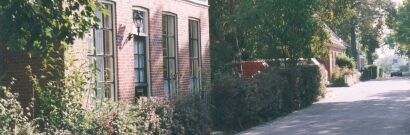
The Dorpstraat en de houses alongside this road are situated on the " hoge Wierde ",which means "high mound" In the curve of the road, on one of the pictures on this page you can see the almshouse. This asylum was granted to the village by the Lady of the Manor and was restored and renovated in the eighties. |
|
|
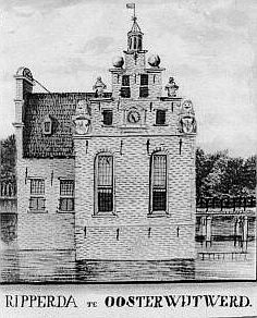
The Manor is the stronghold Ripperda unfortunately demolished after 1745. The grounds of the stronghold can still be seen on the east-side of the village, behind the house called "de Wijtwerder Heerd". In recent years the moat has been restored. In the battle between the Town-city and the surrounding country about 1500 the village played a strategic role in the battle of Appingedam. The "Manor of Oosterwijtwerd", shown here on a later drawing from the record office was occupied by the Town-city shortly after new year 1500. They fortified the manor and encamped an army of 60 men at the grounds |
 |
|
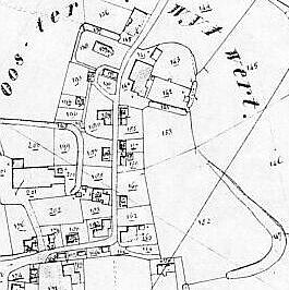
This map dates back to about 1825, when the land registry office began an inventory. By clicking on this map you will reach a page with several maps of Oosterwijtwerd in the last two centuries.
|
| During the Second World War there was substantial fighting around Oosterwijtwerd. A dozen dwellings were destroyed or severely damaged. One corner of my own house was damaged by a Canadian tank which ran into it and a grenade blew away another corner. After the war the houses were rebuild or restored and on the south side of the village new housing has been established along the Ripperdaweg. | 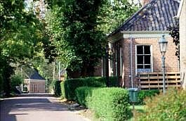 |
|
The aspect of the Dorpstraat (which is the main street of Oosterwijtwerd) has changed dramatically in the 20th century. Most of the houses on this street used to be shops except for number 7, at present a building contractor. There used to be a smithy at no. 9, a bakery at no. 11, a school at no. 15, a tailor at no. 10, a seamstress at no. 12, a cooper/cartwright at no. 28, a shoemaker at no. 30, and a grocery at no 32. |
|
| The inhabitants of Oosterwijtwerd
The inhabitants of Oosterwijtwerd are mostly an industrious, modern people. Many are self-employed persons, others with jobs in surrounding cities and villages or even abroad and very few unemployed. The retired and elderly are usually very active till life forces them to rest. Most family households make use of the computer and Internet and since 1990 we have a cable television network. Fortunately we also retained some good habits from the past. We still have time for one another, we greet each other in passing and speak out each others name and when somebody needs assistance, there usually will be someone spontaneously giving it. |
|
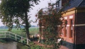 |
Veldzicht, at
the entrance to the village and situated on the river, is a good place
for a break during a cycling trip or canoe tour through the wide and open
landscape of Groningen. The terrace is situated in the sun on the waterfront
and boats are able to moor at the terrace.
If there is snow and ice in winter the place is crowded and lively with skaters who come to eat pea soup or drink a hot chocolate. |
| The pub is cafe and diner all in one and the center of most of the activities of corporate life in the village. Most meetings take place at this location and in winter the skating club organizes its contests on the river outside | |
| The building contractor Henk Slagter owns the place on Dorpstraat 7. | |
| Vd Kooi Architectural Design is situated at Dorpstraat 11 | |
|
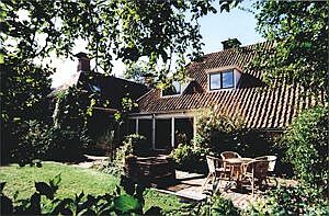
When visiting this part of Groningen there is accommodation to be found with Jim and Betty Lambeck at the Wijtwerder Heerd, Dorpstraat 20, Tel (+31) 0596 627453. More information about this on our page of the "Wijtwerder Heerd" Behind this residence the grounds of the stronghold can still be seen. In recent years the moat has been restored and a large signboard explains the history of the place and also gives information about the project on the "Little Owls".
|
|
| Antiquarian Bookshop "De Blauwe Aarde" is situated at number 32 | |
|
|
|
| The edifice Rehoboth opposite the church houses the studio of artist Janke Poortvliet who lives at Dorpstraat 11. Janke is one of the persons who winds the church-clock and if you want the keys to the chapel for a visit she is the one to address. | |
| Artist Annet Tuinier Hofman also lives in Oosterwijtwerd at the Ripperdaweg 23 | |
The FarmersThe farmers nowadays are the managers of modern agrarian business. Farming, in these parts, has changed to cattle in recent years. The assiduous re-allotment in recent years is also rapidly changing the old historical landscape with its winding creeks, gently sloping fields with wide open views and small Hawthorn thickets into the flat standard Dutch polder-model. The Nameless Farm at Schoolweg 2 is 62.50 ha Farm "Meelenbrij" at Schoolweg 15 is 1.29.30 ha and the rest of the land of the farm is owned by "Bureau Beheer Landbouwgronden". E. Hillenga en H. Ekema live here. The Nameless Farm at Schoolweg 17 is 57.91.26 ha and since 1998 fam. Salden live here, originally from Limburg with red and white diary cows. A new large barn was build in 1998.
Farm "Rieuwersveld" at Damsterweg 23 is 47.15.35 ha. Since 2003 fam. Hingstman live here. Before them, from 1993 till 2003 J. Hulleman and G.A. Winters lived here with a herd of cows. Farm "De Hoop" at Damsterweg 41 is 1.00.75 ha. Since 1990 family Luchtenberg live here. Farm "Batenburg" at Damsterweg 43 is 2.61.00 ha . The original farm burned down in 1915. This place is found in historical books as a stronghold. Johan Westenberg and his wife Ria Meijer live here with their children
The White Nameless Farm at Krewerderweg 2 is 39.54.30 ha. The house is rented but land and barn are owned and used by N.E. Smit en E.G. Boelema with the farm in Krewerd. Since 1990 they have Limousin cattle. This is the only "eco" - farm in the village. Farm "Berlerheerd" at Krewerderweg 4 is 49.06.70 and used as a dairy farm by Nico en Linda van den Akker. A new large barn was build in 1992.
|
 The
Dieftil school is to be found at the
three forked road between the villages of Oosterwijtwerd, Leermens and
Eenum. They have their own school-homepage
(in Dutch only) The
Dieftil school is to be found at the
three forked road between the villages of Oosterwijtwerd, Leermens and
Eenum. They have their own school-homepage
(in Dutch only) |
|
|
Clubs
|
Football is played at the field in a neighbouring village Zeerijp, where they also have the clubhouse. Fivel voetbalclub Zeerijp
|
| The Municipality: Loppersum
No. of inhabitants: app. 11.050 Other villages in this municipality: Eekwerd, Eekwerderdraai, Eenum, Fraamklap, Garrelsweer, Garsthuizen, Hoeksmeer, Honderd, Huizinge, Kolhol, Leermens, Loppersum, Lutjerijp, Lutjewijtwerd, Merum, Middelstum, Startenhuizen (ged), Stedum, Stork, Toornwerd, Westeremden, Westerwijtwerd, Wirdum, Wirdumerdraai, 't Zandstervoorwerk, 't Zandt, Zeerijp, Zijldijk (ged) |
|
 |
| Nederlands |
| [ Mijn tuin ] [ Tuinen ] [ Rozen ] [ Compost ] [ Kruidentabel ] [ Bloementaal] [ Flora & Fauna ] [ Ecologie ] |
| [ Oosterwijtwerd ] [ Pasen ] [ Steenuilen ] [ Ransuilen ] [ Oogstmijt ] [ Groningen ] [ Logies ] |
| [ Spiritualiteit & gezondheid ] [ Vegetarische pagina ] [ Vrouwen ] [ Internet ] [Links ] [ Index ] [Top pagina] |
| English pages |
| [ My garden ] [ Herbal Garden ] [ Gardens ] [ Links to Roses ][ Language of Flowers] |
| [ Who am I ] [ Books and literature ] [ Pets ] [ Flatcoated Retrievers ] [ Oosterwijtwerd ] [ Little Owls ] |
| [ Flora, Fauna and botany links ] [ Ecology ] [ Spirit and health] [ Vegetarian page ] [ Women ] [ Homepage ] [Top of this page] |
| all rights
reserved copyright ©1997 - ©2013 |
this
is a private site, not a company |
|
|
|
||
|
Sending unsollicited non-personal commercial messages to the (e-mail) addresses on these pages is not permitted. |
 The
Nameless Farm at Damsterweg 1 is owned by the family Folkersma.
They have a herd of sheep.
The
Nameless Farm at Damsterweg 1 is owned by the family Folkersma.
They have a herd of sheep. The
Nameless Farm at Damsterweg 4 has 2 ha. With its large stables it
is a good place for people who love horses.
The
Nameless Farm at Damsterweg 4 has 2 ha. With its large stables it
is a good place for people who love horses.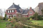 The
Nameless Farm at Dorpstraat 33 is a dairy farm owned since 2001
by Benedict en Thea Wesselingh.
The
Nameless Farm at Dorpstraat 33 is a dairy farm owned since 2001
by Benedict en Thea Wesselingh.